Below is your video forecast from North Texas Storm Center.
Below is your 7-Day Forecast:
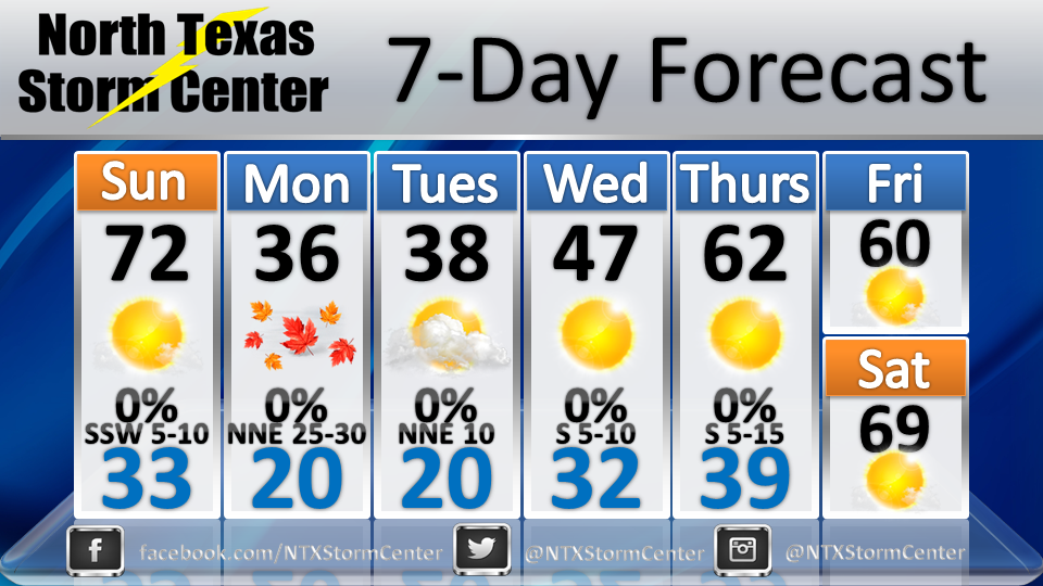
7 Day Forecast as of 1-26-14
|
Below is your video forecast from North Texas Storm Center. Below is your 7-Day Forecast:
7 Day Forecast as of 1-26-14
0 Comments
As we approach the end of the work week, we may begin to see travel and road conditions begin to deteriorate as a winter storm moves into North Texas. This event is much different than the last winter precipitation event the saw just last week, and models are showing close to a 100% chance that we will see wintry precipitation in North Texas, as well as icy and slick roadways (this includes the DFW Metroplex) late this week. We will break down the timing and what to expect of this winter weather event in this blog post. Below is an image from the NWS website showing the area where a winter storm watch has been issued (counties shaded in blue are under a winter storm watch): 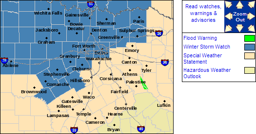
Current watches and warnings from the National Weather Service as of December 3, 2013 at 9:45 PM CDT.
WEDNESDAY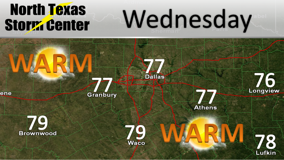 During the day on Wednesday During the day on Wednesday Enjoy the beautiful, warm day while we have it. Tomorrow, on Wednesday, we will see mostly sunny skies across the region with highs in the upper 70's and a wind out of the Southwest at around 5 to 10 mph. WEDNESDAY NIGHTOvernight Wednesday During the overnight hours Wednesday night, we begin to cool off and see lows around the upper 30's by midnight Thursday morning. A cold rain will begin to move into North Texas overnight, late, freezing rain is not expected. THURSDAYDuring the day on Thursday During the day on Thursday, we could still be seeing some cold rain around the region during the morning hours, however Northern areas of North Texas could see some freezing rain, lasting until around noon. After noon, we may see a break in precipitation until the late afternoon hours roll around. THURSDAY AFTERNOONDuring the afternoon on Thursday Thursday afternoon, the precipitation will return and we could begin to see freezing rain and ice around North Texas in the areas shaded in purple, THIS INCLUDES THE METROPLEX, however, areas Southeast of Dallas and Fort Worth will most likely see only a cold rain. THURSDAY NIGHTOvernight Thursday Overnight Thursday, we will see temperatures dipping down into the 30's & 20's in most areas and freezing rain turning to ice continuing overnight into Friday morning. Be sure to give yourself extra time during you morning commute as roadways, especially elevated roadways, could and most likely have ice on them. Also, be extra cautious of 'black ice' as well, black is ice that is not visible but does pose a risk to lose control of your vehicle. There will also be a possibility to see some more wintry precipitation on Friday, and on into the weekend. I will have another blog post to break down the timing and chances later on. 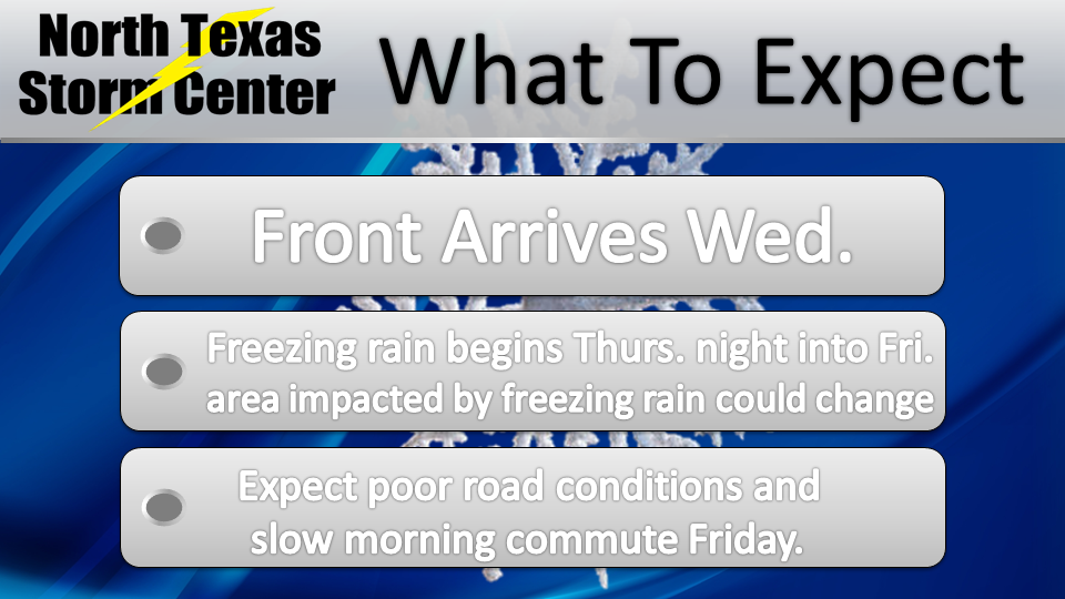 What should we expect from this winter storm? > Cold front arrives Wednesday. > Freezing rain begins Thursday night, lasting into Friday. > Poor road conditions, slow morning commute on Friday. > More winter precip. possible over the weekend. > Possible power outages, icy roads, and likelihood of having to remain at home for several days. Stay with North Texas Storm Center for the latest on the winter storm as it closes in on North Texas!Images from NWS Ft. Worth Website: |

Categories
All
|
